Google Earth Flight Simulator is a free online flight simulator game developed by Google. It was first introduced in 2008 and has been updated on a regular basis since then and fed with the latest satellite technologies.
You can use Google Earth Flight Simulator to simulate real life flights through the use of Google Maps and Google Earth. The game allows users to fly any aircraft across many locations in the world.
The best thing is, you can even share your experiences, like findings, exploring mysteries, and flying over hidden islands with others through different online forums like Reddit, AVSIM or by posting pictures or videos taken during the flight.
Here you will get to know how to use the Flight Simulator. So, in order to fly around the 3D World, you need to download the latest version of Google Earth Pro on either a desktop, mobile or laptop.
Keep in mind that the Google Earth and Flight Simulator combination will not work if using an online browser. That’s why it’s crucial to have a stable internet connection on the PC or Mac on which you download Google Earth Pro (free of cost), so that it can render images easily and produces high quality.
What is Flight Simulator on Google Earth
Flight Simulator is a Google Earth product that allows users to fly in the cockpit of an aircraft and see the world from above. It allows users to fly around and view objects on the ground from above, as well as control various aspects of the aircraft such as altitude, speed, etc.
The interface is simple, with a list of locations you can fly to and from, a list of airports where you can land, and a map showing where these are. The user can choose an airport name or an airport number; if they don’t know the name, they can click on the number to get a list of possible matches.
Once you select an airport and click “start”, you’ll be taken to that airport’s page in Flight Simulator.
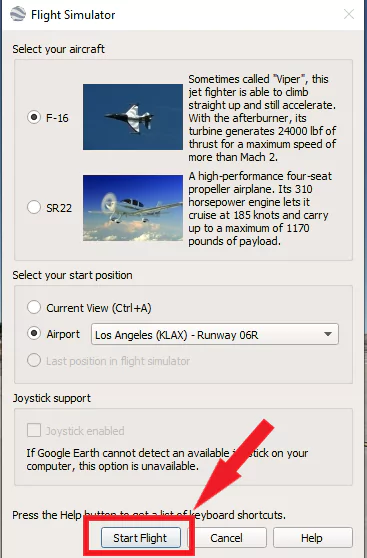
You’ll see your plane on this page as well as some basic information about it. The user can also view their plane’s performance statistics here:
The simulator uses Google Maps for navigation purposes (just like any other flight simulator), so locations are rendered based on what’s available within the map at any given time (which means that if you’re flying over oceans or areas with no data coverage, your mileage may vary).
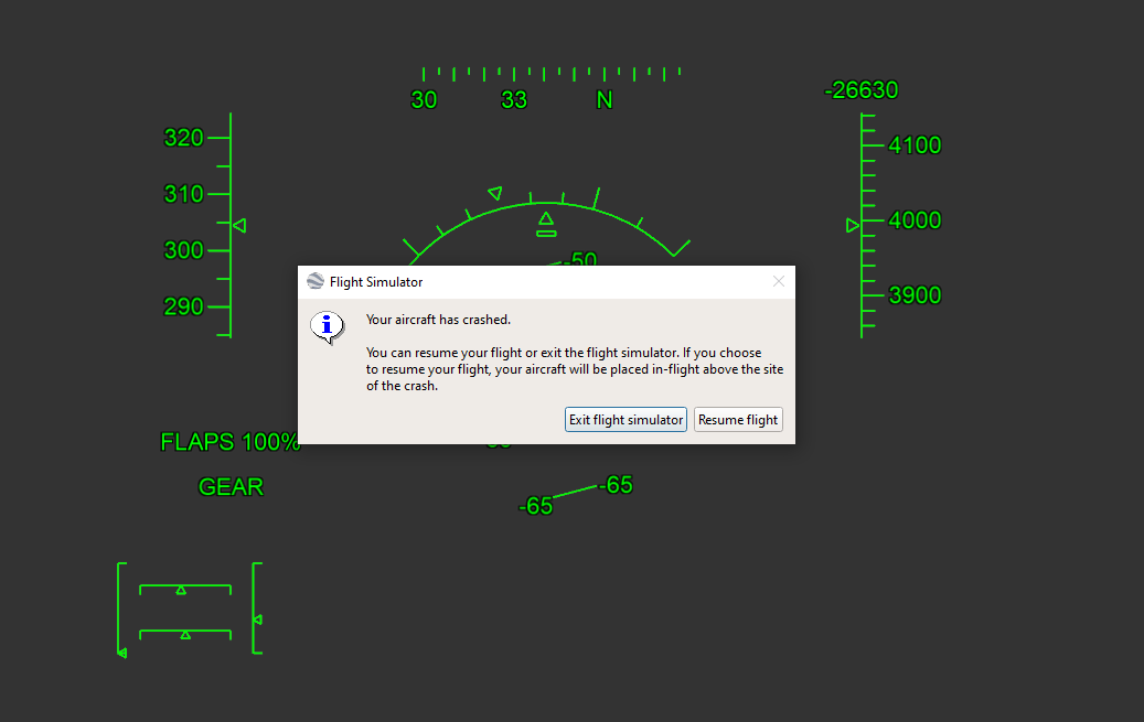
The graphics are high quality and the controls allow you to enjoy your flight while still getting a sense of the realism surrounding you. If you crash your plane, Google Earth prompts you with the option to either exit the Flight Simulator or resume your flight!
Included with the game are more than 100 cities from around the world that have been scanned using photogrammetry technology.
Surprisingly, players can fly through these cities, land on buildings and interact with them. They can also search for landmarks, view photos of buildings, take pictures of clouds and terrain and even fly over tropical islands.
However, you should also note that it’s not a Flight Simulator but just a free ride of Google Earth’s Platform rendered images which they take and refresh from time to time via the satellite. So, before comparing it with other astonishing games through which we can learn piloting and aviation like Microsoft Flight Simulator 2020, or X-plane, keep in mind that it’s not a game, and neither a flight Simulator.
Also, it doesn’t have as many planes or other flight systems as we can see in the MSFS or other flight simulators.
How To Use The Flight Simulator On Google Earth
The first thing you need is the Google Earth Pro windows or Mac version installed. After installing it, follow the below steps to start your 3D aviation journey.
#1: Launch Google Earth Pro
The first step is to launch the Google Earth Pro App on Windows or mac.
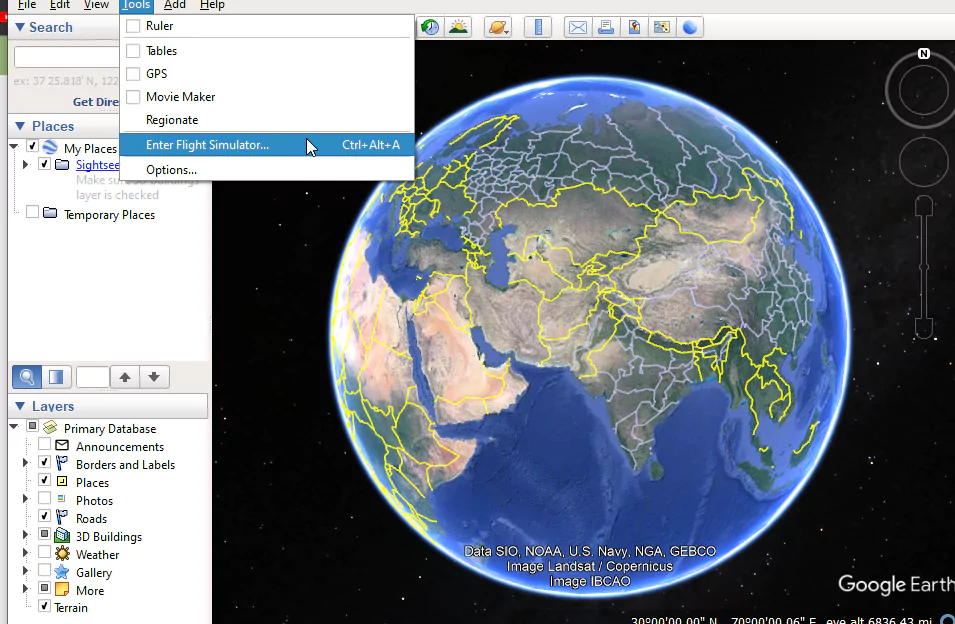
#2: Tap on Tools
After launching, tap on tools of the app, and launch Google Flight Simulator. To do this, you can also press CTRL+ALT+A.
#3: Set Up Your Flight Preferences
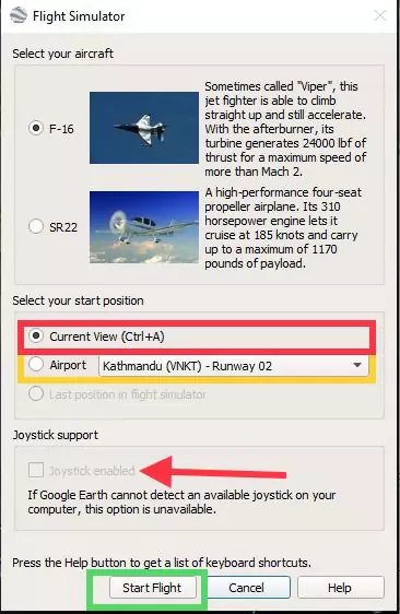
A small window will now open. The three sections of this window are as follows: aircraft, start position, and joystick.
#4: Choose Your Aircraft
You can choose from either an F-16 at 280 to fly or the SR22 if you want to moderately fly and enjoy your flight over the moon.
#5: Take Off Position
You can always choose the tradition” starting in New York “. Google also have created a more fun variation where you can start from your last stop on the flight simulator. The Seattle airport is a popular choice for advanced pilots who go with F16.
#6: More Fun With Joystick
- Select the checkbox to indicate that the current airplane you are using is equipped with an individual joystick.
- Click on start flight, and it will load up the airport or your current location. We always add love to fly from the beginning and choose the Seattle or New York or you can go will Las Vegas airport.
- Check labels and borders to identify other airports that are in your way. This way you will be able to fly with a proper pattern, and you will know all the locations where you have visited it will surely increase your fun and your aviation experience.
Understanding The HUD Of Your Plane
Airplane HUD (Heads Up Display) is a proof-of-concept that provides users with the information they need to guide them through a virtual flight. It is configured to deliver pertinent environmental and navigational information as well as act as an interactive tutorial.
Also, it also serves a secondary function as an engaging game that can be enjoyed as a standalone product or as part of flight training software.
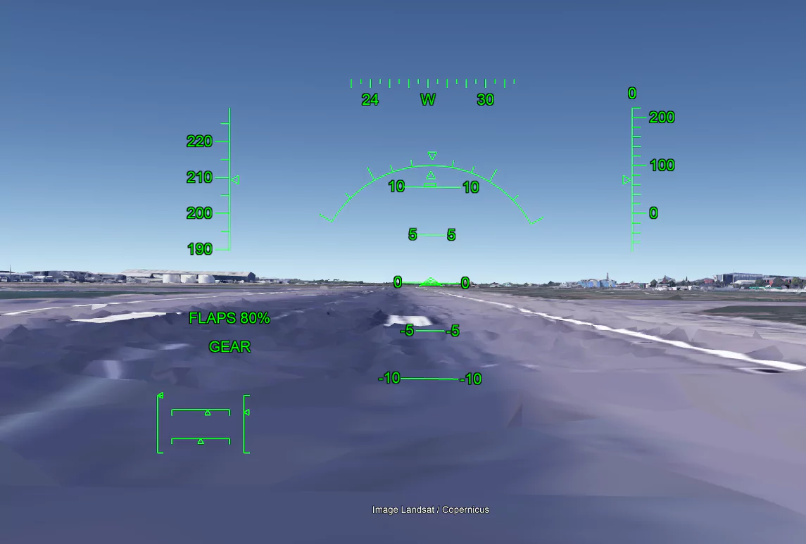
So, once you are in the flight and every thing is a place, you will see a green layout in front of your screen. It’s like you are in the cockpit of your Google Flight Simulator plane. Now, let’s figure out how to manage and fly your plane.
Get To Know More About The HUD
- Starting at the top left, you’ll see the speedometer for the plane.
- Moving counterclockwise, next up is your compass-like display that shows your directional heading.
- Next down is a set of numbers written vertically; these correspond with a number of lines unlabeled below them and are used to calculate your plane’s altitude in feet per minute.
- Below that, your altitude in feet above sea level is displayed. By default, the value should be displayed as 4320.
- In the center of your screen, you will find a compass with other displays near it. This is called your main HUD or Heads Up Display. The needle in the center with smaller needles surrounding it is an indication of your bank angle, which tells you at what angle you’re flying through the air by showing you on what side of the plane you are facing as it crosses through horizontal lines that signal different degrees of attacks and pitches.
- The bottom left-hand corner of the photo will have a box, whose left side resembles a joystick. The top side will resemble a big red button. The right hand is like a mouse, and the bottom right-hand corner is just some kind of toggle or dial.
- Above is the reading for your flap indicator in percent and also the landing gear status. The SR22 does not have retractable landing gear so that part can be ignored.
The real fun begins now;
How To Control Google Earth Flight Simulator Plane
In this flight simulator, you control the plane using your keyboard or gamepad. Pressing forward on the arrow keys makes the plane dive, and pushing back on the arrow keys makes it climb higher in the sky.
More so, if you look to make the nose of your plane rise, then hold down “up” on your keyboard or gamepad instead. In simple words, all the controls are inverted, so it’s not like a racing game.
- Prepare for Takeoff: If your plane is starting to veer off course, try pressing left or right on your keyboard with the comma or period buttons respectively to help guide your plane back towards the runway.
- Go take off: Click on the airplane, move your mouse button down and then press the page-up key (and the FN key on Windows computer). By increasing thrust and accelerating with full throttle you can move down the runway at 280 knots until takeoff speed is achieved. Once reaching V1 speed, lift off into the air!
- Take turns: If you want to move your jet to the right, press the right arrow key gently, and don’t try to push it, or it will crash the plane. In contrast, if you want to fly to the left, do the same with the left key.
- Fly Upwards and Downward: Now you’re handling with care. So, if you want to have some fun and fly to the sky, move your cursor to the bottom, or press the up arrow key. To come back to Earth, and fly in a limit, press the downward key or move your cursor upwards.
- Pause the Flight: You can press Space Bar to pause the flight. P.S; that’s how I have written this tutorial.
- Emergency Exit: If your Mum has called you to get some tomatoes from the grocery store or have dinner, you can simply press the Escape key to leave the flight and jump through the virtual window.
How To Land Google Earth Flight Simulator Plane
Landing in the Google flight sim is a bit complex for beginners, but it’s not that harder. To land on your favorite airport;
- After hovering and flying around the world, it’s time to land. To do this, pick your favorite Airport and fly towards it. Press Page Up to increase the thrust until it reaches 650 knots.
- Align your plane so that the path you have plotted (the runway) is completely vertical, and your HUD is in the center. Remember, it’s the cockpit of your plane.
- Now, press Page Down to decrease the speed, throttle, and thrust.
- To control the flaps, tap on F which drastically slows down your F16 jet.
- The best way to land is to do with the arrows keys. However, you can land via the mouse cursor, but it’s not our favorite.
- Gently press the Down Arrow key to bring your plane closer to the ground.
- Get a heads-up of your HUD and check your Altitude and sea level.
- Make sure you’re slow enough to land, otherwise your jet will crash, and you’ve to do all this process again.
- It’s important to do your due diligence and not just trust in your instincts because they might lead you wrong where it concerns landing safely by air. When you make your final descent to the ground from whatever altitude it is you’re flying at, take it nice and easy. Do not go too fast or dive aggressively. Beware, you could crash your plane.
- If you’ve crashed, simply press Exit Flight Simulator to start over. Or, if you press resume Flight. If you choose this option, the flight will resume from the place you crashed.
Lastly, note that the flaps must be retracted before attempting to stop. To retract the flaps, please press and hold the Shift key while tapping the F key. You will begin to move at a degree of 10 m/s.
Ensure you have sufficient runway ahead of you in order to run at this speed and take care to not hit anything or damage your plane. When you’re ready to bring the plane to a complete stop, please press both comma (“,”) and period (“.”) keys together.
How to Change the Camera View on Google Earth Flight Simulator
Luckily, you can change the camera view of Google Flight Simulator Plane. To do this follow the below steps;
- Step 1: Onboard on a Flight via The Google Earth Flight Simulator.
- Step 2: In order to move the pilot’s camera view to the left, press the “Alt” and “Left Arrow” keys simultaneously. In order to move the pilot’s camera view to the right, press the “Alt” and “Right Arrow” keys simultaneously.
- Step 3: Press CTRL+LEFT ARROW/RIGHT ARROW to move pilot view left/right.
Frequently Asked Questions:
How Do You Go Faster On Google Earth Flight Simulator?
Turn off the flaps from the side window. After that, long press Page Up key to go faster and fly around the World. However, if you’re not able to turn the flaps off, hold Shift and press F.
How To Remove the HUD overlay On Google Earth Flight Simulator?
If you don’t like that greenish HUD overlay in front of your cockpit, just remove it. We recommend you only this, if you’re experienced enough to fly without it. Otherwise, you won’t be able to have fun.
Down the road, there are a variety of ways to remove the green HUD (Head’s Up Display) overlay graphic on the flight simulator in your airplane.
- One way is to press the H key repeatedly until the HUD disappears.
- You can also use your joystick’s hat switch and toggle through different options until you find an option for ‘HUD off’. Then you can play without all of those pesky green markings, but should still be able to see where everything is.
Does Google Earth Flight Simulator Have Autopilot?
No. Google Earth doesn’t have an Autopilot feature. However, if you want to enjoy flying on autopilot and sightseeing, just go to tools and enable normal navigation mode. Although, it’s not like an autopilot mode but, you can still visit around the globe without pressing a single button.
Other than that, you can use GoogleGeorge. It’s an open-source plugin, or you can say a separate app that’s integrated with Google Earth Pro and helps you enjoy everything on an Autopilot.
What is Google Earth?
Google Earth is an online mapping and geographic information system (GIS) developed by Google. It allows users to search and view in 3D the current or past state of the Earth’s surface.
Google Earth differs from other mapping systems such as Microsoft Bing Maps or Yahoo Maps, because it allows the user to fly around in a three-dimensional environment.
Down the road, the program displays satellite images of the earth, aerial photography, elevation data and street maps. Users can also explore their city or neighborhood using Street View panoramas or virtual tours.
Why you Should try Google Flight Simulator?
There are a number of ways to use Google Earth Flight Simulator, but the most important thing is to get the most out of it.
There are three main purposes of using Google Earth Flight Simulator:
- Using Google Earth Flight Simulator as a tool for research of the world’s precious places through the Google Earth’s massive satellite renders.
- Using it as a virtual world in which you can view and interact with real-world airports and airfields.
- Using Google Earth Flight Simulator as a basic training platform for future pilots who want to get a minimal hands-on training of the HUD. Talking about the training, it’s just for the virtual flight, and you can spare some time to have fun by digging deep in to the World’s 3D map. Also, it enables you to understand the very basics of HUD like flaps control, Aviation, Altitude and speed. Although, you should not take it seriously, because it’s made for fun purposes, not for learning flight system, nor it has any other learning curve.
Is Google Earth better than other Flight Simulators?
Well, to be honest, comparing Google Earth Flight Simulator with other true-to-life Simulators which use real-time data from cloud servers is not worth it. Here, you will only get two planes name (not actually planes which you can view) to fly with. Also, you can’t interact with players. In other words, it’s just an animation flying over the things that Satellite captures and make renders of. Purposely, it’s made for people who are bored at home and can’t afford to play, or they are just starting in the sim world!
Is Google Earth Flight Simulator realistic?
Google Earth Flight Simulator is not realistic, only the places are rendered upon real places captured by NASA’s Satellite. The simulator is not at all realistic because it is only the name that ties it to the Google Earth.
Flight Simulator is about flying on an aircraft, controlling it and making it land at the desired destination. What you see on the screens are not the actual aerial view that you get from the aeroplane. In the case of Google Earth Flight Simulator, it is just a visual treat for the players, but it has nothing to do with the aeroplane.
Conclusion
Google Earth Flight Simulator is an excellent feature of the Google Earth Pro platform. Its user interface is a bit confusing, however, and its functionality isn’t so readily apparent. To learn how to make use of this wonderful app, you can check out the above tips and tricks.
Given the latest update, which includes terrain and textures, it’s clear that Google still takes Earth, and flight simulator enthusiasts, seriously. And all of you who have been waiting for this trick, go ahead and try it out for yourself. Because even seasoned pilots need a good refresher every now and again.
